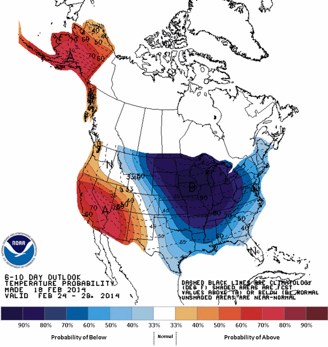
Remember that time when a giant pattern of Arctic air descended over the U.S. and Canada, freezing everything in its path? Remember when it came back ? Yeah, that’s all happening again.
Here’s Wunderground’s Jeff Masters ,
who completely buried the lede with something about a “major February
thaw” across the Midwest U.S. before delving into this forecast of
horrors:
Fortunately (?)To reiterate, that’s temperatures 20 to 35 degrees below normal. Over much of the easter two-thirds of the country. We have six to ten days to prepare.
for the Midwest, this week’s thaw will be short-lived, preventing the
kind of major flooding that would result if all of the snowpack were to
melt in a week.
This morning’s runs of the GFS and European models were better able to
handle the evolving upper-air pattern over the Pacific Ocean, and it
appears that their earlier runs seriously underestimated the strength of
a ridge of high pressure forecast to build over the Western U.S. 6 – 10
days from now. This ridge will be accompanied by a return of the cold “Polar Vortex” over the Midwest and Northeast U.S., bringing bitter cold temperatures and strong winds.
Temperatures 20°F below normal will likely invade the Upper Midwest on
Sunday, and gradually spread southeastwards during the week.
The peak cold is predicted to occur late next week, with temperatures
20 – 35° below normal covering much of the eastern 2/3 of the country.
Here’s what it’ll look like:
NOAA/CPC

No comments:
Post a Comment